First Generation Lidar Elevation Data for Minnesota: 2008-2012
Explore information and resources for understanding and accessing 2008-2012 (first generation) lidar data and derivatives for Minnesota.Background
The goal of this project was to develop and deliver a seamless high-accuracy digital elevation map of the State of Minnesota, based on data collected using lidar technology. Accurate topographic information will greatly enhance the ability of decision makers and resource managers to understand how water interacts with the landscape and will provide the foundation for developing innovative, effective, and defendable resource management strategies. The project will facilitate the flow of data between all levels of government: local, state, and federal.
In July 2009, the Minnesota Legislature appropriated $8.3 million ($2.8 million each in fiscal years 2010 and 2011; $1.35 million each in fiscal years 2012 and 2013) from the Clean Water Fund of the Clean Water, Land and Legacy Amendment to help realize the goal of creating a seamless elevation model for Minnesota by filling in the areas where data either did not exist or was deemed to be old enough to be replaced. The project was coordinated by MnGeo's Digital Elevation Committee.
On October 2, 2014, the project received a Governor's Geospatial Commendation Award.
Accessing the Data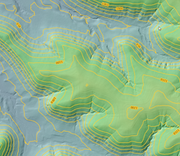
- MnTOPO2: A web application for viewing, printing and downloading high-resolution elevation data for Minnesota collected using lidar technology
- View terrain data and contour lines, choose from several basemaps, view flight lines and metadata
- Create, save and print a map
- Find the elevation of a point and draw elevation profiles
- Download lidar data by drawing a polygon around your area of interest
- MnTopo2 will provide a text document including links to download sources
- MnTopo2 FAQ
- MnGeo's FTP Site
- Help Introductory documentation for the FTP site and the data; the main ones are listed below:
- readme_first.rtf: Description of how the files on the FTP site are organized and what is in each folder.
- raw_LiDAR_Data_README.rtf: Description of the tiled lidar point cloud information (LAS format) and the tiled file geodatabases storing derived information.
- county_mosaic_readme_first.rtf: Description of the files in the county mosaics and tips for using them.
- LAS_File_Processing_Using_LASTOOLS: How to work with LAS/LAZ data format and how to export to a neutral format that can be imported into other software such as AutoCAD.
- If you haven't used this site or lidar data before, see the help files. Some of the paths given in the readme files need updating. Please let us know (gisinfo.mngeo@state.mn.us) if you have trouble finding anything.
- Contents of county geodatabases: This table summarizes the derived products found in each county geodatabase since not all counties are identical (e.g., not all counties have a building footprint layer)
- Unzipping problems: Some older unzip programs cannot handle the extended zip format used to compress these large files. If you have unzipping problems, try using 7-zip on Windows and the standard zip/unzip programs on other operating systems.
- Flight lines and dates of acquisition (where available):
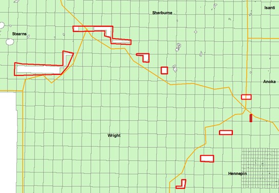
- Problem with some LAS files in Stearns, Sherburne and Hennepin counties, near Wright Co. border
- The following files are missing some data (see graphic with missing areas outlined in red): 3542-22-07, 3526-22-59, 3542-25-16, 3526-19-62, 3542-26-14, 5158-08-11, 3542-20-03, 3526-22-60, 3526-22-57, 3526-19-64, 3542-21-05, 3542-20-02, 3542-26-13, 3542-24-16, 3542-19-01, 3542-28-12, 3542-28-11, 3526-19-63, 3542-30-09, 3526-22-56, 3526-22-58, 3526-21-61. If they can be fixed, replacements will be published.
- Help Introductory documentation for the FTP site and the data; the main ones are listed below:
- ArcGIS 10.1 Toolbox (MnDNR): Streamlines downloading and merging lidar data associated with a polygon of interest from within ArcGIS software Requires ArcGIS 10.1 Service Pack 1 or above.
- Hillshade layer: Lidar-derived, black-and-white image on MnGeo's WMS image service - see the 2008-2012 Hillshade Metadata
Areas Covered
See the project area map- Arrowhead
- Duluth Area: (Fall 2012, after the spring 2012 flood)
- Maps showing area covered
- Duluth area documentation
- This data replaces the corresponding tiles in the Spring 2011 Arrowhead collect EXCEPT in the "arrowhead" project folder, the "previous" folders in the q250k folders, and in the county mosaics.
- Data is available for download from the "duluth_fall_2012" projects folder, the q250k folders, and the county folders (the tiles but not the county mosaics).
- Remaining Arrowhead Region (Spring 2011)
- Carlton, Cook, Lake, and St. Louis counties, part of Itasca County, and Voyageurs National Park in Koochiching County.
- Remaining Arrowhead Region Coverage Map showing block boundaries
- Remaining Arrowhead Region documentation
- Data is available on the FTP site in different places, depending on whether or not it has been replaced by the 2012 Duluth Area collect:
- If it has NOT been replaced by the 2012 Duluth Area collect, 2011 data is available in the "arrowhead" projects folder, the q250k folders and the county folders.
- If it HAS been replaced by the Duluth Area collect, 2011 data is still available in the "arrowhead" projects folder, in the "previous" folder in the q250k folders and in the county mosaic (but not the tiles) in the county folder.
- Duluth Area: (Fall 2012, after the spring 2012 flood)
- Central Lakes (Spring 2012)
- Aitkin, Cass, Hubbard, Itasca, Todd and Wadena counties and a portion of Koochiching County.
- Central Lakes documentation
- Central Lakes Coverage Map showing block boundaries
- Data is available for download from the projects folder, the county folder and the q250k folder.
- Twin Cities Metro (Spring and Fall 2011)
- Anoka, Benton, Carver, Dakota, Goodhue, Hennepin, Isanti, Kanabec, Meeker, Mille Lacs, Morrison, Ramsey, Scott, Sherburne, and Washington counties.
- Twin Cities Metro documentation
- Twin Cities Coverage Map showing block boundaries
- Data is available on the FTP site both by county (in the county folder) and by block (in the projects folder). showing block boundaries.
- Tile naming for the Dakota Block, Metro Block and Maple Grove Block: Since the point density of these collects is higher than the other blocks (2 points/square meter for the Dakota Block, and 8 points/square meter for the Metro and Maple Grove blocks), the vendor tiled the las files further, breaking each standard tile into 16 additional tiles. They are simply appended an A, B, C, or D starting in the upper left and proceeding in a clockwise direction. A sample image, taken from the tile index map that is on the site, shows a single tile with the sub-block lettering scheme. A sample tile name would be: 4243-02-30_a_a.laz. Also, there is a tiling scheme feature class in the elevation_data file geodatabase.
- Red River Basin (Spring 2008 - Spring 2010)
- 19 1/2 Minnesota counties: Becker, Beltrami, Big Stone, Clay, Clearwater, Grant, Kittson, Koochiching (northern part), Lake of the Woods, Mahnomen, Marshall, Norman, Otter Tail, Pennington, Polk, Red Lake, Roseau, Stevens, Traverse, and Wilkin.
- Red River Basin documentation
- Red River Basin Coverage Map showing block boundaries
- Data is in the county folder of the FTP site.
- Derived Red River Basin products: Overview of derived products for the Red River Basin, 7/15/13
- Southeast (Fall 2008)
- 8,800 square miles in 9 counties: Dodge, Fillmore, Freeborn, Houston, Mower, Olmsted, Steele, Wabasha and Winona.
- Minnesota GIS/LIS Consortium Newsletter featuring the Southeast lidar collection
- Southeast Region documentation
- Southwest (Spring and Fall 2010)
- 17,260 square miles in 25 counties: Brown, Chippewa, Cottonwood, Douglas, Faribault, Jackson, Kandiyohi, Lac qui Parle, Le Sueur, Lincoln, Lyon, Martin, Murray, Nicollet, Nobles, Pipestone, Pope, Redwood, Renville, Rock, Sibley, Swift, Waseca, Watonwan, Yellow Medicine.
- Southwest Region documentation
- Other Counties
- Blue Earth 2012 (also available: Blue Earth 2005)
- Independent county projects: Chisago, Crow Wing, McLeod, Pine, Rice, Stearns, and Wright
These counties are available for general distribution via agreements between these counties and the State of Minnesota and/or the U.S. Geological Survey. Pine County is available by agreement with the Natural Resources Conservation Service.
- Smaller Projects
- Lake Superior Bathymetry: Hydrographic and topographic data collected along the Lake Superior coast of Minnesota, Wisconsin and Michigan for NOAA. Data extends offshore from the shoreline to extinction depth or 1 km, whichever is closer, and onshore from the shoreline to 30 meters.
- Lake Shady: A reservoir on the Zumbro River in Olmsted County
- Mille Lacs Kathio State Park: In Mille Lacs County; see park description; data from an independent project centered on the park.
- Minnehaha Creek: In Hennepin County, data from a U.S. Army Corps of Engineers project
- Minnesota River Basin, South Dakota portion: Minnesota Red River Basin, South Dakota documentation. Data is in UTM Zone 14 coordinates
- Red River Basin Block I: Covers Lake of the Woods and Roseau counties, eastern Marshall County and northern portions of Beltrami and Pennington counties.
- Seven Mile Creek: In Nicollet County
- May 2012 Lidar Survey Results on user needs for lidar data
- Change log of problems fixed:
- Twin Cities Metro Block A_C: 32 tiles (10/19/12)
- Arrowhead Block 4: tile 2742-02-53 (12/11/12)
- Morrison and Cook county tiles (3/7/13)
- Carver County building footprints (3/11/13)
Additional Resources
- Hydrographic Position Index Technical Report: Combining lidar-derived DEM analysis, raster classification and color symbology for pseudo-3D terrain visualization to enhance hydrography interpretation on the DEM landscape