Minnesota Air Photos - FSA, USDA: 2002
Through the National Agricultural Imagery Program (NAIP), the Farm Service Agency collects color imagery used to monitor U.S. Department of Agriculture farm programs.
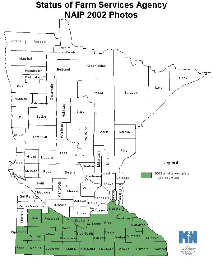
Twenty-eight agricultural counties in southern Minnesota were flown in June-August 2002 and the 1-meter resolution imagery was orthorectified. The original files are in GeoTIFF format; the U.S. Army Corps of Engineers, St. Paul District, created a county version in MrSID format.
- Quarter quadrangle files: Purchase from the Aerial Photography Field Office in GeoTIFF format
- Documentation and map of the 28 counties
NAIP 2002 Aerial Photography: MrSID County Files
From links in the table below, download county mosaics of NAIP 2002 (National Agricultural Imagery Program) aerial photography for 28 counties in southern Minnesota. These MrSID format mosaics were created by the U.S. Army Corps of Engineers for the U.S. Department of Agriculture's Farm Service Agency.

Download county mosaics
Each link points to a self-extracting zip (.EXE) file. After downloading, double-click the .exe file from Windows Explorer or File Manager. The following files will automatically be extracted:
- Data files: the image in MrSID format (.sid extension) and its accompanying header file (.sdw extension).
Naming conventions:- Each file is named "fsa_countyname_mosaic_2002".
For example, the image file covering Brown County is named "fsa_brown_mosaic_2002.sid" and its accompanying header file is named "fsa_brown_mosaic_2002.sdw". - When more than one file is needed to cover a county, the "countyname" part of the filename is followed by a letter (n = north, s = south, ne = northeast; nw = northwest).
For example, the image file covering Blue Earth County is named "fsa_blue-earth_n_mosaic_2002.sid" and its accompanying header file is named "fsa_blue-earth_n_mosaic_2002.sdw".
- Each file is named "fsa_countyname_mosaic_2002".
- Metadata: documentation for the data set. Two records are included:
- naip02.html: This record applies to the entire NAIP 2002 data set.
- fsa_countyname_mosaic_2002.sid.xml: This record applies to a specific mosaic file.
For example, the "fsa_cottonwood_s_mosaic_2002.sid.xml" file contains bounding box coordinates, UTM Zone and photo dates that apply to the Cottonwood County south file, rather than to the whole NAIP 2002 data set.
|
County Name |
Download File Size
|
Photo Dates (2002) |
UTM Zone |
| 213
162 |
6/29-7/29 | 15 | |
| 328 | 6/29-7/1 | 15 | |
| 190
176 |
6/29-7/1 | 15 | |
| 341 | 7/13-8/9 | 15 | |
| 226 | 7/13-8/9 | 15 | |
| 324 | 6/29-8/8 | 15 | |
| 384 | 7/30-8/11 | 15 | |
| 178
178 |
7/13-8/8 | 15 | |
| 398 | 7/28-8/11 | 15 | |
| 277 | 7/30-8/9 | 15 | |
| 187
188 |
6/9-7/1 | 15 | |
| 244 | 7/13-7/28 | 15 | |
| 201
203 |
6/28-6/29 | 15 | |
| 169
172 |
6/29-7/1 | 15 | |
| 156
154 |
7/30 | 15 | |
| 242
187 |
6/28-7/1 | 15 | |
| 155
145 |
6/29-7/28 | 15 | |
| 166
154 |
6/28-7/1 | 15 | |
| 334 | 7/28-8/11 | 15 | |
| 109
157 |
6/28 | 14 | |
| 141
137 195 |
6/29-7/1 | 15 | |
| 249 | 7/13-8/9 | 15 | |
| 246 | 6/28 | 14 | |
| 248 | 7/13-8/9 | 15 | |
| 308 | 7/28-8/11 | 15 | |
| 263 | 7/13-8/2 | 15 | |
| 249 | 6/29 | 15 | |
| 405 | 8/8-8/11 | 15 |